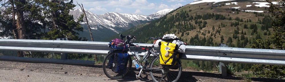

Starting in Sunnyvale, CA, I went north along the coast into Oregon, then started making my way east. This black line shows my way across the country and then back west and south to New Orleans, where I caught a train to Los Angeles. From there, I cycled to Monterey.
The route, the route! There’s a lot to say about the route. Of course you have to plan a route if you want to cycle across the country. But you also have to be willing to be flexible. Things happen. Weather, for example. Road closures. Finding out that a campsite you wanted to stop at for the night no longer existed. Something way cool that you just learned about 50 miles to the south that you cannot pass up. Rumors of a crazed dog down the road that will chase you across three county lines.
Basically, my route plan bears a lot of similarities to Rick’s speech plan. You know, Rick! Of Rick and Morty?

Make a plan, but plan to break the plan and make stuff up, too.
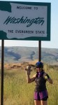
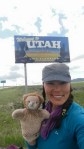
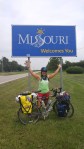
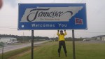
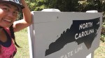
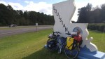
But in the end, this picture of the map sums it up pretty well. If you count the gratuitous border crossings done just to bag states, I rode my bike in eighteen states: California, Oregon, Washington, Idaho, Utah, Colorado, Kansas, Missouri, Illinois, Tennessee, Kentucky, Virginia, North Carolina, South Carolina, Georgia, Alabama, Mississippi, and Louisiana. Below is photographic evidence with signage. Except for California, since I started there and rode the train back. And Kentucky, because I rode a tiny ferry across the Mississippi from Missouri and there were no state signs around.


The Wiggle. People often ask why I did so much wiggling across the country, rather than taking a more direct route. There are many reasons. For one thing, because I could. I had no big time pressure and I wanted to spend more time out on the road. Yes, crossing the country was my goal, but I had other goals, too. I wanted to meet as many people as possible and raise awareness for bone marrow donation. It certainly seemed reasonable to me to spend more time covering more ground in order to meet more people. Also, I wanted to get to know my country more, and I especially wanted to get to know the Pacific coast more intimately since I consider it my home. Then there were the sites I’d never visited and desperately wanted to see. I wasn’t able to make them all, but I was determined to make it to Bryce Canyon and Zion National Parks in Utah. So I had lots of destinations in mind besides the Atlantic Ocean.

Zion National Park. I took this photo. Really!
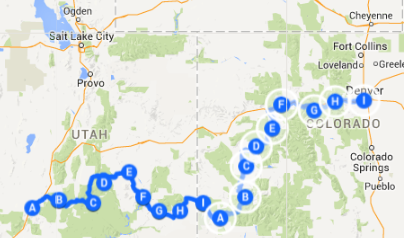
Don’t routes already exist? Established cycling routes, especially those from Adventure Cycling, structured a lot of how I planned my route, but I veered away from them significantly because they tend to go through tiny towns. That’s fantastic, it makes for great riding, but my interest was in visiting cities where I could attend events for Be the Match. For example, that’s how I ended up in Denver. I don’t think many cross country cyclists decide to go through Denver…

Flooding made it necessary to change the route into Denver by climbing Independence Pass and crossing the Continental Divide at 12,095 feet.

Do you see it? I wrote my name across the country with my bike! Sort of. If you borrow the northern borders of California and Nevada. By accident!
Why Atlanta? People often ask me why I didn’t conclude my ride at the coast. I made it to Charleston, South Carolina and dipped my wheels into the Atlantic Ocean at Folly Beach. Transcontinental ride done, yes? So why did I keep going? Well, again, because I could and because I wanted to spend more time raising awareness for Be the Match. But mainly because I wanted to conclude in Atlanta. My sister Cindy lives there, which is close enough to the Atlantic coast to make that my final crashing place, but not close enough to actually touch the water. Plus, she plans one amazing end-of-the-ride celebration! She also pointed out to me that at this point, my route kind of spelled my name. Huh.

Celebrating the conclusion of the ride at Emory University with all these amazing people making bone marrow transplants possible!
So what’s with the Big Easy? How did I end up going to New Orleans? As much as I was thrilled to be riding for Be the Match, I wanted some time to ride just to ride. To not have to constantly think about routes and schedules and meeting people and going into cities. When I was in Knoxville, some cyclists were telling me about the Natchez Trace Parkway. The beauty of it was that you could escape and just be away from civilization for a while. That doesn’t fit with doing an awareness ride, but it sounded awfully tempting. Since it starts in Nashville, I was seriously tempted to ride back up to Tennessee and ride the entire thing. The clincher came when my cousin Sabrina told me that she would be in Nashville in a couple weeks. Sometimes things just work out too perfectly. I rode up to Nashville, got onto the Trace, and after arriving at the end in Natchez, Mississippi, it was only too logical to go to New Orleans. I’d never been there and wanted to see it! Plus Amtrak goes there, so from there it would be easy to get home.

Here’s me with Jared, my nemesis walking counterpart. Go team Walking Across Amarrowca!
Amtrak, eh? As it turned out, I got to New Orleans with just enough time to enjoy the city a bit, then hop onto the train just in time to see Jared Reichbaum of Walking Across Amarrowca complete his cross country walk for Be the Match in Long Beach! Again, sometimes things just work out too perfectly. I got to attend a Be the Match 5k with Jared and his crowd, and then it only made sense to ride back home, hopefully arriving at the doorstep just in time for Thanksgiving.
Little help! I didn’t quite make it. I had promised myself that I would never cycle north along the Californian coast ever again, but somehow I had forgotten just how fierce that wind can be. Plus it was cold and rainy. So I made it to Monterey the day before Thanksgiving and my sister Lori drove down to pick me up. I wanted to be home for Thanksgiving. Close enough.

Surprise whiskey in my bedroom! My family’s the best.
Just for fun, below I’m keeping my thoughts and plans for the route as they evolved. It’s messy, but that’s how it goes. My original words from February are in grey. Things that I added later are brown. Maybe red? Burgundy? Well, let’s say a different color.
As I type this, it is mid February and I’m snug warm in my house with fuzzy pants on as the fog limits my view of the outdoors. I’m thinking about making a cup of tea.
From this vantage point, the concept of climbing onto a bicycle with all of my possessions stuffed into a few bags and heading off for a distant campsite seems distant and unworldly. Am I being too optimistic, trusting Future Self to be capable of feats that Present Self can only vaguely imagine? I don’t know.
These maps will either help me plan my trip successfully or provide hilarity later on as hindsight laughs at my unrealistic expectations and naiveté.
So here it is, in all its glory: My planned route from Mountain View, California to Portland, Oregon; to Bryce Canyon National Park in Utah; to Denver, Colorado (that’s new!); to Yorktown, Virginia; and then to Atlanta, Georgia.

Don’t trust this map too much! I drew that blue squiggly line with a track pad on a Chromebook. More detailed and accurate Google maps are below.
First of all, credit goes to where credit is due. I did not come up with these routes all on my own. I purchased maps from Adventure Cycling and I am piecing together their Pacific Coast, Western Express, and TransAmerica Trail routes. There are bits and pieces that I invented with the help of Google Maps, but mostly I’ll be traveling some well-beaten paths. Cortney and Sue and I used an Adventure Cycling map when we traveled to Santa Barbara, and it was excellently detailed.
So here are the more detailed maps, please click on the images to access them through Google Maps where you can zoom and explore all you want.

Map 1: Mountain View to Crescent City, April 19 to April 29.
Map 1: From Mountain View to Crescent City, from April 19 to April 28, will mostly follow Adventure Cycling’s Pacific Coast Trail. I will be departing from Prometheus CrossFit on April 19, hopefully with lots of people celebrating the fact that they won’t see me around the box for four months.
Update in early May: Okay, so we’re amending that – I left on April 19 from my sister Lori’s house in Sunnyvale, wiggled my way up to SF, and got onto the Pacific Coast Trail rather successfully. I got into Crescent City on April 29, so hey, that wasn’t such a bad estimate!

Map 2: Crescent City to Portland, April 28 – May 8
Map 2: From Crescent City to Portland, from April 29 to May 8, will also mostly follow the Pacific Coast Trail from Adventure Cycling. Because it seems like all grand adventures have to include Portland, of course I’ll be cutting through there, hopefully meeting up with friends!
Update in early May: Excellent, things seem to be going according to plan. I got into Portland on May 5, though I cut out the part of going up to Tillamook. Instead, I took 18 from Lincoln City, stopping for a night in Willamina. And Kevin and Sunyoung arrived on the train from Seattle on May 8, and we headed out towards Boise!

Map 3: Portland to Salt Lake City, May 9 – May 30
Map 3: From Portland to Salt Lake City, from May 9 to May 23, is a route that I am borrowing from my friends Kevin and Sunyoung. Because of construction, part of our planned route is closed to bikes, so we’ll be forced to ride a shuttle. Oh darn. This is a portion of the route that I am doing out of pure stubbornness. There are a lot of ways to get across the country that do not involve going hundreds of miles south after going hundreds of miles north. However, I really want to visit Utah. Because it’s Utah!
Update in late May: The route from Portland to Boise came together pretty much exactly as planned, but then I stayed in Boise for a bit longer than I thought I would, but it was a great decision. On May 20th I took off on my own again and the route started to get more rugged. I didn’t arrive in Salt Lake City until May 27 and am planning on leaving on Friday, May 30.

Map 4: Salt Lake City to Bryce Canyon and Zion National Parks and Cedar City, May 30 – June 9
Map 4: From Salt Lake City to Bryce Canyon National Park, from May 30 to June 5, is again a route of my own invention to stubbornly make my way to these national parks that I’ve always wanted to see. There are so many beautiful areas in this world, but for some reason Bryce Canyon and Zion National Parks just call to me. And just maybe some family may come out to join me for a vacation in these parks!
Update in early June: I left Salt Lake City on May 30 and was able to hang around Red Canyon, Bryce Canyon, and Zion until June 9, when I made my way to Cedar City! My planned time to take a break and do some sight seeing went pretty much as planned!
Map 5: Cedar City to Denver, June 10 – June 28
Map 5: From Cedar City to Denver, from June 10 to June 28, will mostly be planned around Adventure Cycling’s Western Express Route, but then I’m turning away from it in order to get to Denver. This section will be gnarly, I’m sure, but my friend James will be with me!
Update in early July: This was a pretty gnarly section indeed, and much of it had to be tweaked due to flooding. I rode from Cedar Springs, UT to Cortez, CO, mostly on the Western Express Route, and met up with James in Cortez. We then rode up to Glenwood Springs, but flooding of the bike routes along 70 made us change our plans. Instead we went to Aspen, then over Independence Pass to cross the Continental Divide. From there we went to Buena Vista, then rode along 24, 9, 285, and some lovely bike paths to finally arrive in Denver on June 27th. James caught a flight back home on the 28th.

Map 6: Denver to Pueblo, July 2 – 6
Map 6: From Denver to Pueblo, from July 2 to 6, joins up with the TransAmerica Route. Gentle downhill?
Update in early July: I did not expect to have a bunch of delays in this section! I got to spend some lovely rest days in Denver with my friend Matt and his wife and son, so it should have been a breeze to keep going. However, it was the fourth of July when I was in Colorado Springs, and it seemed smart to not ride on that particular day. Later I had way too much fun in Pueblo, the CrossFit gyms were so welcoming and I didn’t want to leave!

Map 7: From Pueblo to Alexander, July 8 to July 14
Map 7: From Pueblo to Alexander, from July 7 to July 12, is where I’ll join up with Adventure Cycling’s TransAmerica Trail. Nothing to do but just follow directions all the way to the Atlantic Ocean! How hard can it be? And the map doesn’t even include an elevation guide!
Update in late July: It’s hot. It is so fantastic to be back on an established cycling route. There are lots of cyclists to hang out with, the towns all know we’re coming and are super welcoming, and it’s hot! We try to wake up as early as possible and start riding while it’s still dark. Hopefully we’re done riding before we spend too long out in this ridiculous heat.

Map 8: From Alexander to Girard, July 15 to July 20
Map 8: From Alexander to Girard, from July 13 to July 20, continues along the TransAmerica Trail. Here the trail traverses the Great Bend Prairie.
Update in late July: I love the TransAm, but surprisingly, I’m starting to miss making my own route. I veered away from the route for a day to visit Wichita and more CrossFitters. It was fantastic.

Map 9: From Girard to Murphysboro, July 21 to July 28
Map 9: From Girard to Murphysboro, from July 21 to July 28, continues along the TransAmerica Trail. The Ozarks here will be tough, but hopefully not as tough as the Rockies.
Update in early August: I’m spending a lot of time riding with another TransAm cyclist. These Ozarks got ridiculous. They’re fun, like a roller coaster, but exhausting and perhaps not necessary. We heard from a local that the TransAm seems to seek out the steepest hills. So now we’re mostly asking locals for route advice. Indeed, their advice flattens out the route considerably. We’re both kind of tired of the TransAm now and would like to spend some time exploring the Mississippi.

Map 10: From Murphysboro to Berea, July 29 to August 6
Map 10: From Murphysboro to Berea, from July 29 to August 6, continues along the TransAmerica Trail. I’m looking forward to some excellent bourbon here!
Update in late August: Oh good gosh no, this did not happen at all as planned. My cycling buddy and I got tired of just following the TransAm and wanted to make up our own route and explore places that weren’t already so well traveled. So we poked our noses into Illinois, then headed down into Tennessee. We went back into Missouri and found a place where we could cross into Kentucky by ferry. Locals told us that we absolutely had to visit the Land Between the Lakes and we spent a few days camping there. We probably would have stayed longer, but my dad and my sister Lori were flying into Louisville! It’s pretty interesting to find ourselves in small towns where cross country cyclists are rarely seen. Few people seem to know that the TransAm exists not very far from them.

Map 11: Berea to Christiansburg, August 7 to August 13
Map 11: From Berea to Christiansburg, from August 7 to August 13, continues along the TransAmerica Trail. Now we get to experience the Appalachians. Why can’t this country be more flat?
Update in late August: Oh, no, nothing like this happened, either. After a super fun visit from my dad and sister, I decided to not continue on the TransAm, still feeling a little stifled by it, and also I wanted to visit Cookeville, Tennessee and CrossFit Mayhem. And so I was back in Tennessee and rode to Knoxville. I had many route decisions to make. Part of me wanted to make it to Yorktown. Part of me wanted to listen to the locals and visit Asheville, North Carolina. But my cycling buddy, who had continued on the TransAm, was in Damascus, Virginia, looking for a bike part. He couldn’t find it, but I found it in Knoxville. So I decided to ride it to him. What’s 200 miles of riding between friends?

Map 12: From Christiansburg to Yorktown, August 14 to August 20
Map 12: From Christiansburg to Yorktown, from August 14 to August 20, continues and completes the TransAmerica Trail. I plan on dipping my wheels into the Atlantic Ocean at the end of this section! But I’m not finished with riding yet.
Update in early September: No no no, this is all wrong. After meeting up with my friend in Damascus, we explored some excellent bike trails in Virginia and mostly relaxed. I knew that I had to be in Charleston by September 2 for Be the Match events, so I figured I didn’t have time to make it to Yorktown. But the direct route to Charleston wouldn’t take long, so we just hung out in Virginia being lazy for a few days. Then I headed south, rode part of the Blue Ridge Parkway, cut through Charlotte, North Carolina – luckily getting to attend more Be the Match stuff – and took a direct route right to Charleston. Straight into a mighty storm.

Map 13: Yorktown to Atlanta, August 21 to September 2
Map 13: From Yorktown to Atlanta, from August 21 to September 2, is my invented route. I’ll try to hug the coast as much as I can before I turn inland to Atlanta. In Atlanta I’ll see my sister Cindy and her family! She and her husband Eric have twins, and I can’t wait to tell my niece and nephew that I cycled across the country to see them!
Update in late September: From Charleston I did not decide to turn west back to Atlanta. It was far too tempting to explore the Atlantic coast a bit. I had ridiculous fun at Hunting Island, South Carolina, and then decided that I wanted to visit Savannah, Georgia again. I had been there years before and had loved it. From Savannah, I made my way northwest into Atlanta, finally concluding there on September 23.
Not included yet, of course, are the stops I’ll be making to attend events with Be the Match and to visit blood cancer patients. So the timeline is pretty rough, but I think that I’ve been generous with the schedule to allow for detours. We shall see how things shake down in the end.
Update in January of 2026: Well. We certainly did.

I would like to see you in Missouri! I can visit my Dad at the same time-yeah!
LikeLike
Excellent! I can’t wait! I don’t suppose we have much chance of hosting a Swabbing and WODing event with your Dad, do we?
LikeLike
Hi Amy,
I went to Fremont with Cindy. I live in NC now, not too far from Greenville. If I know when you’re coming, I’d like to bring my Girl Scouts to meet you en route. This is one of my favorite organizations.
LikeLike